Google Maps: What It Is And How It Works
Google Maps is a geographic application developed by Google that allows you to locate your position, calculate road routes and create customized maps. This is a beneficial free service, like ViaMichelin and Google Translate, which I recommend everyone to download on their smartphone to always have it at hand. In this article, I will explain how to use Google Maps using the free app or the desktop version.
Understanding how to use Google Maps as a navigator, how Google maps work, and how to use all its features is beneficial not only during various journeys by car, on foot, or by public transport but also and above all, during trips in Italy and all over the world. Abroad or to create customized maps.
Google Maps: What It Is And How It Works
Google Maps is a free service available for smartphones and desktops, thanks to which you can take advantage of countless features and services, including:
- Access the Google Maps navigator function to follow directions by car, public transport, or on foot;
- Receive notifications about speed cameras while you are driving;
- Find any place or point of interest (restaurants, bars, hotels, shops, etc.) all over the world;
- Create, save and download customized maps, which are helpful for all travelers.
How To Download Google Maps
To use Google Maps, you must first download the free app for iOS and Android on your smartphone (usually pre-installed on Android devices). Once the Google Maps app is installed, you must log in to your Google account to access all its features.
How To Use Google Maps As A Navigator
With Google Maps, you can use the Navigator function to follow directions by car, public transport, or on foot to:
- Find addresses, streets, squares, etc.
- Find bars, restaurants, hotels, museums, gyms, cinemas, ATMs, hospitals, car parks, pharmacies, car washes, garages, gas stations, etc .;
- Find any shop or business.
To be guided to your destination, click on the Google Maps icon, type in the Search box here the address or point of interest you want to reach in the way you prefer (car, public transport, or on foot), and activate the Google navigator. Each destination is accompanied by addresses, photos, reviews, and telephone numbers.
How To Use Google Maps For Driving Directions
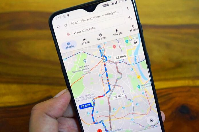
Google Maps can be used to reach a particular place by moving by car, motorbike, or scooter. This is one of the functions most used by drivers, very useful for moving from point A to point B following the fastest route or the one in the way that best suits your needs (with tolls, avoiding tolls, shorter routes, etc.). To use Google Maps for driving directions, enter the address or place of interest in the Search here field, click on Directions, and then on the car icon. The app will display the best route or routes to follow by car and the travel time.
It is also possible to add further stages to the course by clicking the Add stage button. Let’s assume we need to reach Florence from Pisa. Just write “Florence” in the Search here box, click on Directions and add “Pisa” on Choose the starting position. At this point, you must select the means of transport that is the first icon at the top, that of the car. Google Maps will display one or more routes that can be followed by car, showing for each the travel time, mileage, real-time traffic information, the presence of tolls, speed cameras, and all road signs. Once the desired route has been selected, click on Start to start the Google Maps navigator.
How To Activate Safety Camera Alerts
As anticipated, Google Maps also provides information on reporting speed cameras along the driving route. This function, introduced in Italy in May 2019, is available by default on the Google navigator, so you don’t have to do anything to activate it. If there are speed cameras along the route, the Google Maps app will report them on the map by showing an orange icon with a camera. In addition, near the speed camera, the app will release an acoustic signal indicating it, showing the maximum speed allowed.
Also Read: Factoring: How Sales Financing Can Help To Overcome The Crisis
How To Use Google Maps On Foot
Google Maps can also be used to walk to a particular place. This is one of the functions I use most when I travel, especially useful when you do not know the exact location of a home or the fastest way to get there by walking. To use Google Maps on foot, enter the address or place of interest in the Search here field, click on Directions, and the walking man icon. The app will display the exact route to follow on foot and the total travel time. Clicking on Start will start the Google Maps navigator and the possibility of activating voice navigation with directions to reach the destination.
Let’s assume we want to walk from Pisa Central Station to the Leaning Tower. Open Google Maps, write “Torre di Pisa” in the Search here box, tap on the walking man icon and click on Directions. The Google navigator will show the route from your current position ( Your position ): if you are actually in front of the station, leave the situation unchanged; if you are in another place, enter it in the Choose the starting position box. At that point, Google Maps will display one or more paths dotted with blue dots that you can follow on foot, showing the travel time. Once you have selected the walking path to follow, click on Start to start the Google navigator.
How To Use Google Maps With Public Transport
In addition to the car and walking functions, Google Maps can also be used to reach a place or an address by public transport. In this case, open the Google Maps app, write the desired location in the Search here box, click on the train icon, and then on Directions. Google Maps will show the public transport (bus, metro, tram) to take starting from your current position, the one detected by the app itself ( Your work), indicating the relative departure times and travel times.
How To Use Google Maps To Find Restaurants, Bars, And Shops
Another handy function of the Google Maps navigator is that it allows you to find places of interest in the surroundings for your current position ( Your position ). To use it, open the app and click on the Explore icon at the bottom left. At that point, Google Maps will show all nearby businesses, from restaurants to cafes to grocery stores to hotels. Click on the desired category to find all the information accompanied by addresses, photos, reviews, and telephone numbers.
How To Create A Map On Google Maps
Google Maps also allows you to create customized Google maps where you can add places, points of interest, and travel itineraries. A handy function for us travelers, especially since Google maps can be viewed directly from the mobile on the smartphone. To create a custom map on Google Maps, you need to:
- access Google Maps
- be logged into your Google account
- Click on the menu button at the top left (the symbol with three horizontal lines)
- Click on Your places.
- Click on the Maps button and the Create map button.
- Add a title and description to the map.
- Search for points of interest by entering the name or address on the search bar or by positioning the cursor directly on the map
- Add the place by clicking on the Add to map button.
- Each location will appear in the sidebar to the left of the map.
- It is possible to order the individual places included in the map and even add the Levels, as in my map of Madrid in 3 days that you find below, where I have indicated all the places of interest to see day by day following a well-organized travel itinerary with a sequence of different numbers and colors for easier map reading.
Once created, Google maps can be viewed on your smartphone by simply opening the Google Maps app. Open the Google navigator, access the menu at the top left (the symbol with three horizontal lines), click on Your places and Maps and open the desired map. All custom maps created on Google Maps can be modified at a later time, shared on Google Drive or the leading social channels such as Facebook and Twitter, and even deleted.
Google Maps Without Internet: How To Use Offline Maps
If you are traveling without the internet, don’t worry: Google Maps also works without an internet connection. It is possible to use the Google Maps navigation using offline maps: just have downloaded them previously. To download offline Google maps, access the menu at the top left (the symbol with three horizontal lines), click on Offline maps, and choose the customized map. Once selected, click on Download.
Google Maps From PC
As anticipated, in addition to mobile users via the app or browser, it is possible to use Google Maps from a PC. Just connect to the link https://www.google.in/maps/ and follow the same procedure for managing Google maps from mobile.
Also Read: Meta Has To Cope With The First Drop In Sales Since Its IPO